Day 3 (June 13)--San Jose to Santa Cruz

 |
| One of the many dams along the Los Gatos Creek Trail |
All of a sudden, I had this huge wave of fear come over me. I thought was a lot closer to Santa Cruz, and expected to see the ocean as I topped the crest of the last mountain. Now I was at a double fork in the road, and my so well-crafted maps and directions just led to further confusion. I turned up one of the roads, and made a steep uphill climb for almost three miles. All of a sudden, some homes appeared! There was a lady out checking her mail, so I asked, "If I stay on this road, will I end up in Santa Cruz?"
"Nope. Dead end road. You'll have to go back."
My stomach knotted up once again. I'd ridden almost 30 miles, and--once again--was totally lost. I coasted down the hill back to the double forked intersection (which "spoke" with a double forked tongue!). There were no road signs. I tried calling Carolyn on my cell phone, but there were no "bars" on my phone. Nada. I was having visions of being trapped in the bowels of the Santa Cruz Mountains, having to overnight under some log because no one would ever find me! This is NOT how I planned for this to happen.
In desperation, I did the only thing a man could do--choose another road. A few miles later, another fork, another decision. This time I hear a car. I placed my bike precariously in the middle of the road and waved him down. A very well groomed gentlemen in a luxury vehicle slowed to a stop.
"If I stay on this road will it take me to Santa Cruz?"
"Uh, ya. Good luck!"
I waited, staring at him. It must have been the panicked "deer in the headlight--I'm going to die look" that caused him to continue.
"Ok. When you get to Summit, go left. You'll run into Soquel-San Jose Road. Go left and follow the signs to Soquel."
San Jose Road! I just came from there. Ugh. But what I really didn't like hearing was the word "summit." That could only mean one thing. MORE climbing.
Indeed. About 9 miles of steady uphill torture. I kept telling myself that the reward for climbing is coasting! No signs, no markers, no anything. I'm still quite nervous. Finally I reach Summit Road, and begin my decent. There were a few more hills now and again, but for the most part it was downhill.
I did arrive in Soquel. I had no idea where that was. So I went into a convenience store, bought a much needed Gatorade, and asked, "Which way and how far is Santa Cruz from here?"
The middle aged Hispanic woman looked at my disshoveled appearance in my spandex bike outfit, shook her head, and said "By bike? I think it's a long way."
Great! I had estimated --or more accurately, was hoping--it was about 6 more miles down the road.
"Maybe about six miles?" I queried.
"Yes, about six miles. Long way on bike!"
Six miles sounded heavenly to me. I had already biked 53 miles, so six more was nothing.
"Where you come from?" she inquired.
We began talking about my trip, and she became very excited; gave me all kinds of "suggestions" for where to go and what to see. "If you write a book, please let me know!" she requested. I gave her this blog address. Emelda, maybe you are reading this now.
 |
| Mission Santa Cruz |
By this time, Carolyn has learned that if I'm an hour or two "overdue," not to panic. I get to the desitnation eventually. We rendesvoused at Mission Santa Cruz. She had done some "exploring" on her own, and found a superb French bakery in town, and came prepared with a date bar for me to ease my pain.
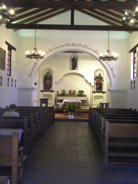 |
| Inside the church at Mission Santa Cruz |
Founded in 1791, Santa Cruz was the twelfth mission established in what was then Spanish Alta California. The local Indians were very receptive, and the soil was rich for agricultural pursuits. The bulding was severly damaged by storms and earthquakes over the years, but the present building dates back to 1891.
Carolyn describes Santa Cruz as "Prescott, Arizona meets the Beach." It has an artful, even slightly western feel, and with the tall trees coming almost right down to the coastline, it does have a bit of an alpine feel. We ate dinner on the Wharf by the historic "boardwalk" of Santa Cruz (more like a "concretewalk"). It seems that Santa Cruz is a somewhat "undiscovered" secret.
San Jose to Santa Cruz: 60 miles (including detours)
Total Missions Visited: 6
Total Trip to date: 195 miles

Wow, getting lost and keeping your cool, I'm impressed. It looks like you are having too much fun! You're an iron man Mark; just keep pedaling. Emelda huh, it looks like the next time you do this trip, either I need to come, or you need to take my class first. Hasta luego chamo!
ReplyDeleteOy! Be careful- you're starting to make us nervous with all this "Where the heck am I?" stuff!
ReplyDeleteWas it Kelly's bakery??
ReplyDeleteVickey--YES, it was Kelly's! A delightful place.
ReplyDelete